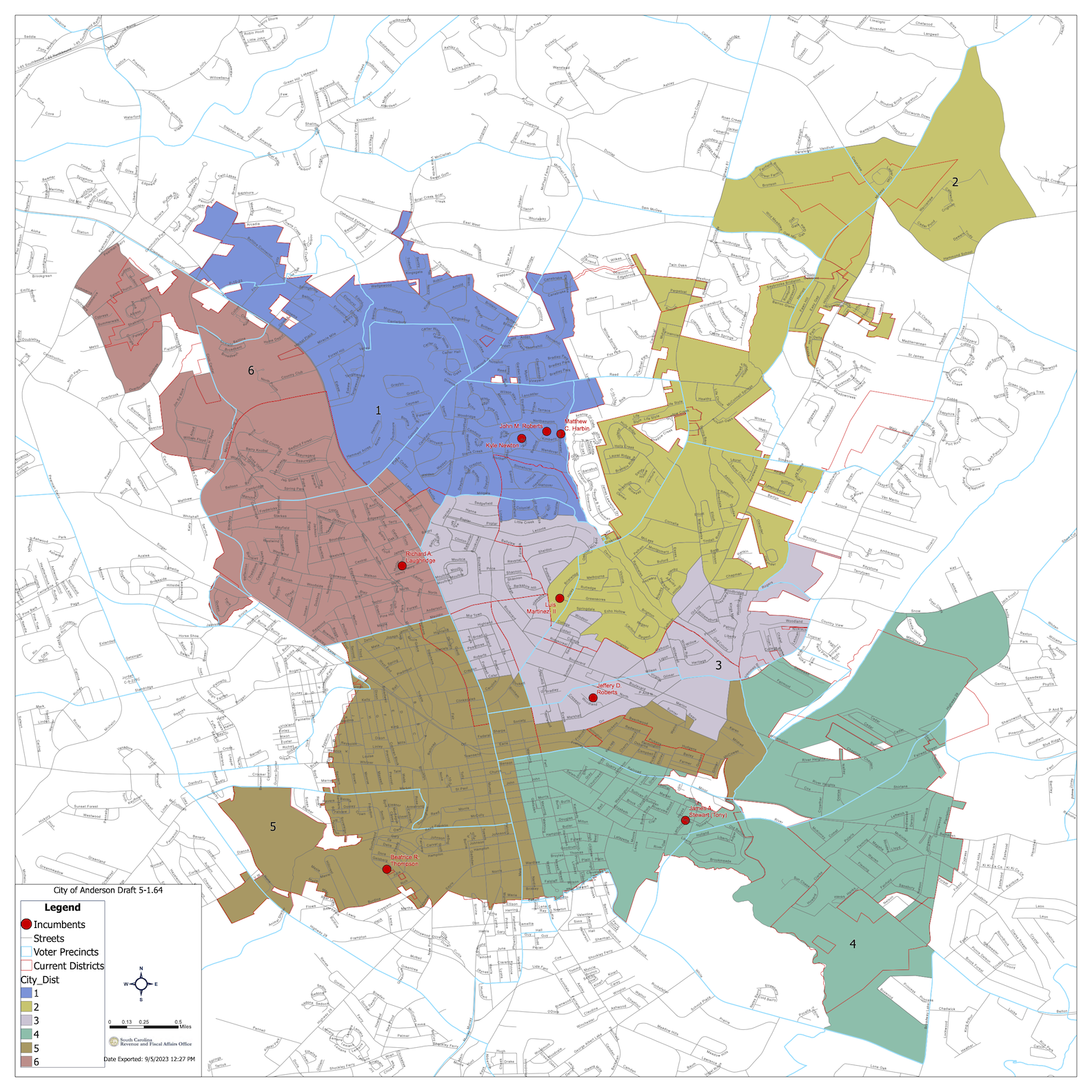
City Council to Vote on Redistricting Map
Greg Wilson/Anderson Observer
Anderson City Council will vote on second reading on the fifth (and potentially final) draft of a redistricting map which will include territory changes for some members of council on Monday at 6 p.m. in the council chambers downtown. A public hearing is planned as part of the process. If approved, the new map will be used in the April 2 municipal elections.
Notable changes on the map, which outlines which area will represent their interests, include:
· A series of blocks bordered by Arlington Avenue, Orr Street, Beachwood Avenue, Pickens Street, Hudgens Street, Gossett Street, with a southern boundary of 310 running from East Whitner Street and dead ending at the Rocky River, currently represented by Area 4 Councilman Tony Steward would be represented by Area 5 Councilwoman Beatrice Thompson under the new map.
· An area bordered by Lindale Road on the east, Stonehurst Road on the north, and Stonehurst Road and Hanover Road on the West, would move from Area 1 Councilman Kyle Newton’s district to Area 3 Councilman Jeff Roberts district.
· An area bordered in the north by Vine Street and Millgate Road, on the west by Lindale Road, on the south by Boulevard, and on the west by North Main Street, would move from Area 6 Councilman Rick Laughridge’s district to Area 3 Councilman Jeff Roberts district.
The map is the fifth revision of a project begun in January with the South Carolina Office of Research and Statistics. The goal is to create a map that will meet the requirements of the law in the most neutral and unbiased fashion, Adam DeMars, GIS & Mapping Section Manager for office told council at their Aug. 28 meeting. DeMars said his team faces limitations of census blocks, data delivered by the federal government which cannot split, to determine the statistical basis for the maps to meet all the metrics.
Throughout the process, the city council provided feedback to the consultants, as well as having open discussions of the process during council meetings held since January.
The redistricting is required to meet legal requirements of the 1965 Voting Rights Act requirements, which mandate redrawing the lines after each United States Census. The proposed map reflects changes from the 2020 census.
Approval of the final map is critical for the Anderson County Voter Registration and Elections to have time to make changes to the voting map before the April 2 municipal elections in Anderson. Officials say even a map approved by early October is expected to put a strain on the elections office.
A divided City Council approved the first reading of the fourth incarnation of the document, by a 5-4 vote, with the promise to make any other minor changes necessary before Monday’s meeting.
Proposed redistricting map for City of Anderson, Draft 5.

