
City Council Gives Initial Ok to New Voting Map
Updated 8/29 with information on map deadline
Greg Wilson/Anderson Observer
Anderson City Council on Monday approved, on first reading by a vote of 5-4, a plan to district the city’s voting precincts.
The redistricting is required to meet legal requirements of the 1965 Voting Rights Act requirements, which mandate redrawing the lines after each United States Census. The proposed map reflects changes from the 2020 census.
Council will also consider any tweaks to the fourth map, and hold a public hearing Sept. 12, before a second and final vote. Approval of the final map is crucial to the Anderson County Voter Registration and Elections to be prepared for the April 2 municipal elections for the City of Anderson, which said even a map delivered in October would put a strain on their office.
The work has been underway since January, when the city partnered with the South Carolina Office of Research and Statistics, a non-partisan organization which has done redistricting work in 39 counties in the state.
City Council has reviewed four drafts since the initial map was released in February, and reviewed three other drafts before voting Monday on the fourth incarnation of the document.
The redrawn districts are required to be of equal population (or as equal as practical) to comply with the Equal Protection Clause of the 14th Amendment which espouses the principle of “one person, one vote.”
Each district must also:
Comply with the federal Voting Rights Act of 1965 to ensure minorities have an equal opportunity to elect representatives of their choice.
Be drawn contiguously, so that all parts of the district are connected to each other.
Minimize the division of voting precincts, cities, counties, neighborhoods, and communities of interest to the extent possible.
Be geographically compact so that nearby areas of population are not bypassed for a more distant population.
Comply with other applicable court decisions and federal and state laws.
The goal is to create a map that will meet the requirements of the law in the most neutral and unbiased fashion, according to Adam DeMars, GIS & Mapping Section Manager for the S.C. Office of Research and Statistics, who has been working on the map for the city.
DeMars said his team faces limitations of census blocks, data delivered by the federal government which cannot split, to determine the statistical basis for the maps to meet all the metrics.
Census blocks represent the smallest geographic area for which the Bureau of the Census collects and tabulates census data, and are formed by streets, roads, railroads, streams, and other bodies of water, other visible physical and cultural features, and the legal boundaries shown on census bureau maps.
“There are a lot of little pieces,” said DeMars. “We did attempt to take all the considerations provided to us by (city) council for the drafts of maps.”
Since the first draft-based on numbers, and the several meetings since requesting feedback which followed, the consultants said they had taken it all into consideration in the fourth draft, within the constraints of federal guidelines.
But some council members expressed concerns about both the map which was given initial approval, and the process itself.
Tony Stewart, Seat 4, repeatedly requested (during the work session and council meeting) the moving of lines in his district to better reflect what he considers keeping neighborhoods intact in his district.
City Manager David McCuen suggested that such changes could mean altering census blocks and cause a domino effect creating other issues for redistricting, adding that suggested changes to earlier maps, including those by Stewart, had already been included in the map which was approved on Monday.
Matt Harbin, who serves in the at-large Seat 7, said that no matter how the lines are redrawn, the citizens of the City of Anderson will be well-represented.
“No matter what, every citizen of Anderson will have full representation,” said Harbin. “I would feel comfortable with anybody on this council representing me, so moving a city block or two blocks to three blocks won’t make much difference.”
Some other council members agreed.
“This is a first reading, there is another reading coming where we can take into consideration other boundaries, because we all know some of these lines are going to fall into other areas, and we know they are in good hands,” said Luis Martinez II, Seat 3.
Martinez said passing first reading will also provide time to give voters some time to get adjusted to the new lines and to let them know who their council member will be under the new map.
But Rick Rick Laughridge, Seat 6/Mayor Pro Tem, who said he was losing much in his district, was adamant that council should vote against the map to give more time for study and citizen input into the project.
“Why are we in such a rush? asked Laughridge, pounding the table.
Anderson Mayor Terence Roberts reminded council all work sessions on redistricting have been available for public comment since the beginning of the year.
The mayor also said there is time for the discussion of any other potential changes to the final map in the weeks ahead.
Any changes to the map approved on Monday will like be the final changes.
“We have provided four drafts already,” said DeMars “Our hope is some solution in where we are at right now. If there are any changes, maybe one more draft is as far as we can go.”
Anderson City Council’s Sept. 12 meeting will include the public hearing on the proposed voting map changes. See current map and map approved on Monday below.
“We are all passionate about this,” said Mayor Roberts. “But we will work together as a team to get this done for the people of the City of Anderson.”
Proposed Map Passed on First Reading
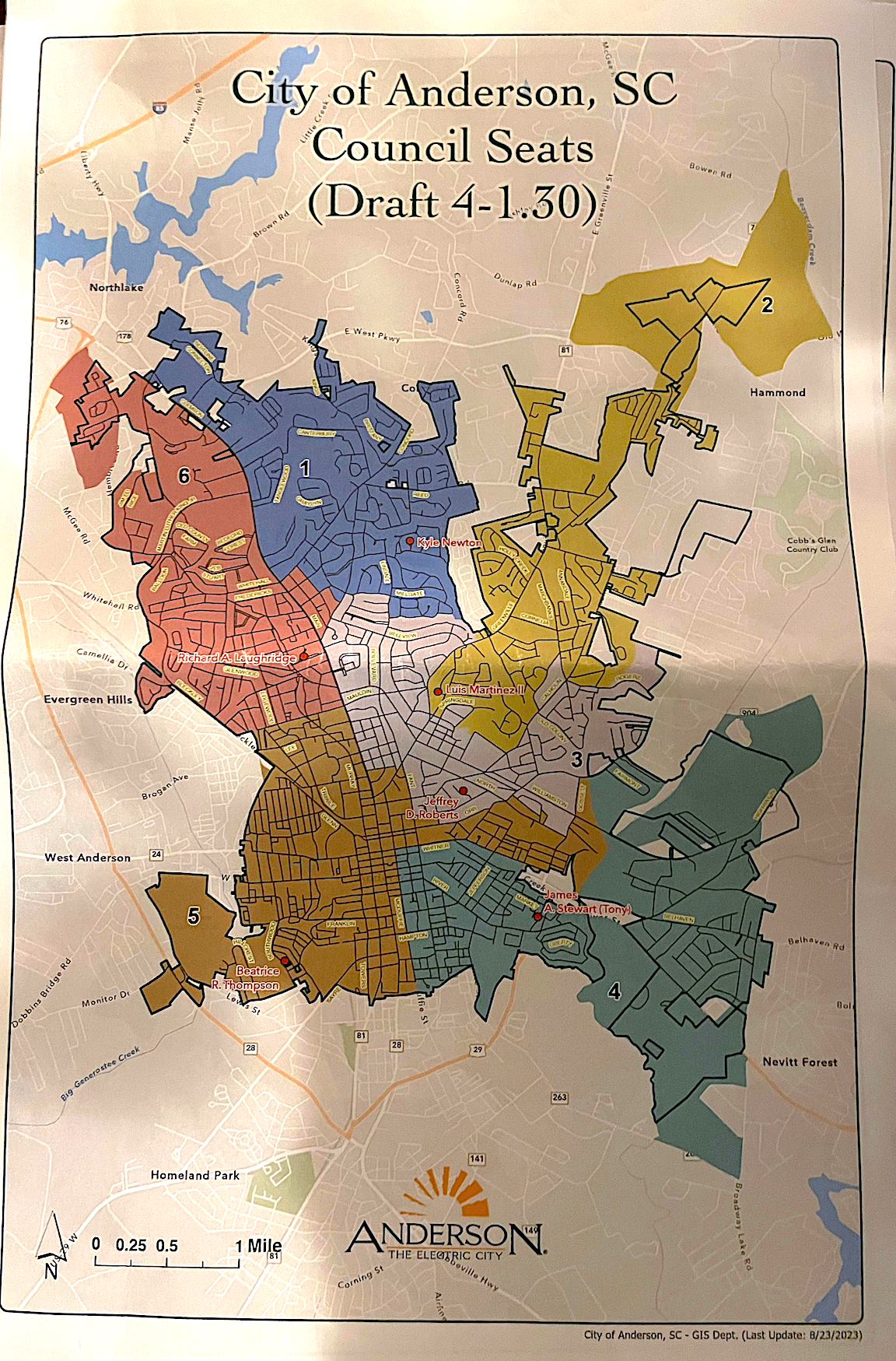
Still needs one more reading a vote from city council to pass.
Current Map
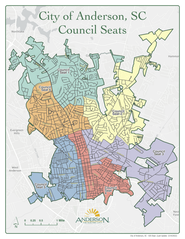
Current City of Anderson voting precinct map.